1950: Nuclear Facility to be Placed in an Arkansas National Park

Screen shot 2016-05-16 at 8.02.44 AM
Screen shot 2016-05-16 at 8.02.56 AM
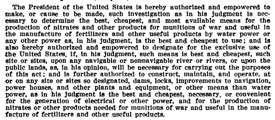
Many dismiss the theory that the federal government would place a nuclear facility within a national park. After reading the 1950 newspaper article at left, I am even more convinced there could be such a facility at Cumberland Gap National Park.


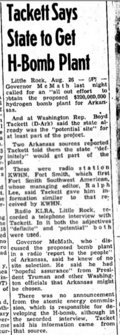
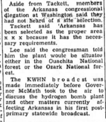
The above article is taken from the Hope Star, an Arkansas newspaper, in August of 1950. Congressman Boyd Tackett has indicated that northern Arkansas would get an H-bomb plant. Although there is no formal announcement from the Atomic Energy Commission, Tackett said “his information came from that source.”  Tackett said “the plant would be situated either in the Ouachita National forest or the Ozark National forest.

Tackett said, “Arkansas has been selected as the proper area…because it has the necessary requirements.”

This story echoes the story of the munitions facility I believe was constructed at Cumberland Gap; the experts recommended the best suited place for the plant yet, in the end, their advice was supposedly unheeded.

The following article details the region’s frustration:

“Several months ago it was announced the government would build a large hydrogen bomb plant in the heart of the Ozarks…It was pointed out the plant would be located in the interior of the country, safe from possible attack from either coast. It would not be possible, it was declared, for an enemy plane to penetrate that far into the interior, or to inflict important damage on this important facility.

But the plans have changed, and instead of being located in this comparatively safe region the plant is to be built in the Savannah Valley, only minutes by air from the Atlantic coast. The proposed plant would be an easy target for enemy bombers.” (2)

The author laments  that “politics” were the reason the plant location was changed; the Democratic party needed their southern voter numbers up. The author believes this was a move to win favor with those voters. I vehemently disagree. The likelihood the plant was installed there all along is a reasonable theory.

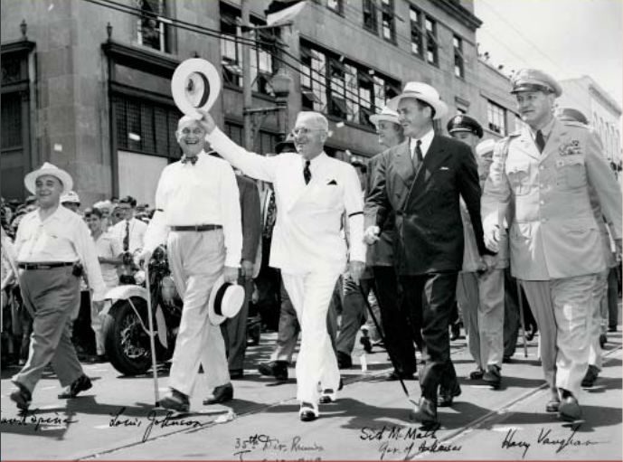
Just as President Wilson possibly visited a secret munitions facility at Cumberland Gap in 1918, did Truman visit a newly completed nuclear facility hidden in the Ozarks in 1952?

Truman may have visited secret nuclear base in the Ozarks in 1952
President Truman visited the Ozarks in 1952, officially to dedicate two dams. Did he visit a secret nuclear facility in the region as well?(3)


(1)”Tackett says state to get H-bomb plant.” Hope Star, August 26 1950.

(2)”Party must be served.” Terre Haute Star. December 14, 1950.

(3) “Presidential Pathways.” arkansas.com.
http://www.arkansas.com/!userfiles/presidential_pathways.pdf

Elevated Amounts of Chromium and Manganese Found in Gap Creek, Tennessee

There are some eye-raising National Park Service water quality reports from the 1990s concerning Gap Creek, which flows through Cudjo’s Cave (or, Gap Cave).

Chromium was found in the creek in measurements up to 70 ug/L (which is equivalent to 70 parts per billion) between the years 1991 to 1996.(1) This is nearing the EPA’s maximum contaminant level (MCL) for chromium in drinking water, which is 100 ppb.

The National Park service tells us that:

Rivers once flowed through the upper chambers of Gap Cave–and Gap Creek still flows through the lowest level of the cavern. Water flowing from the cavern was used to power several mills and the machinery at the Cumberland Iron Furnace in the 19th century. The creek was dammed inside the cave in the 1800’s to create a reservoir that still supplies the towns of Cumberland Gap and Harrogate, Tennessee with drinking water.(2)

When contaminant levels are approaching the maximum levels set by the EPA, and the water supply is a source of community drinking water, it would be reasonable to expect the continued monitoring of contaminant levels in Gap Creek. However, Jennifer Beeler, the Cumberland Gap National Park’s Resource Management Specialist, indicated the water quality reports stopped when the Tunnel construction ended:

That work was done during the tunnel construction with funding from that particular construction project.  After the tunnel was completed that degree of funding for water quality work was no longer available.  We do basic water quality work each month like e. coli, temp, dissolved oxygen, conductivity, ph, turbidity etc, but that is it right now.(3)

Remember when the Middlesboro Tannery was blamed for chromium found in Yellow Creek? Interestingly, it would have been impossible for the tannery to contaminate Gap Creek:

Gap Creek on the TN side of the park comes from Gap Cave, flows through the town of cumberland Gap than Tiprell and then eventually empties into the Powell River.  Little Yellow Creek in the park goes into Middlesboro, flows into Yellow Creek and then eventually into the Cumberland River.  So the two are not connected at all.(3)

Another possible contaminant of concern in Gap Creek is manganese. Overexposure can be responsible for symptoms similar to Parkinson’s Disease, most notably muscle tremors and other neurological damage. Manganese toxicity can also be misdiagnosed as Lou Gehrig’s disease or multiple sclerosis. Children are especially susceptible to manganese toxicity. Currently, the EPA has established a “health advisory level” of .3 mg/L, or, 3 parts per million. However, in 1996, a report by the EPA,

in developing an oral reference dose for manganese based on dietary intake, mentions an epidemiological study in Greece that showed an increase in neurologic effects such as weakness and fatigue, disturbances in gait, and neuromuscular effects, in people whose drinking water contained 1.6 to 2.3 mg/L.(4)

The water quality reports for Gap Creek, where the communities of Cumberland Gap and Harrogate obtain their drinking water, show up to 210 parts per billion, or, .21 mg/L on December 1, 1991 and 270 parts per billion, or, .27 mg/L, manganese on March 23, 1993.(1)


(1) STORET Central Warehouse, EPA.
https://ofmpub.epa.gov/storpubl/storet_wme_pkg.Display_Station?p_station_id=CUGA_CPSU_GC4&p_org_id=11NPSWRD

(2)Cave Handout, National Park Service.
https://www.nps.gov/cuga/learn/nature/upload/cave-handout2.pdf

(3) Email communications, June 23 2015, with Jennifer Beeler, National Park Service.

(4) Drinking Water Notification Level for Managanese, California EPA State Water Resources Control Board.
http://www.waterboards.ca.gov/drinking_water/certlic/drinkingwater/Manganese.shtml

The Airplane Room: Deep Under Cumberland Mountain

The following was written by a guest author who wishes to be known only as The Mysterious Man from Rose Hill. We’ve decided to name this huge underground cave “The Airplane Room” in memory of his father.

This is a story that was told to me by my father when I was 8 to 10 years old in the late 50’s. It was an exciting story for a young boy and I still have vivid memories of him telling it.

Please understand that everything I’m relating is hearsay as I have no way to verify or corroborate the account. My father was a very truthful person. In fact he would often admonish me as a child to never exaggerate or embellish a story. “If you stretch the facts, then no one will believe you when you do tell the truth,” he said.

Following is a recounting of the story as told by my father, as  I remember it:

The setting is in Cumberland Gap, Tennessee where my father lived with his family. The time is the early 40’s. It was the war years, and my Dad was in his early teens.

One night, Dad and two of his friends decided to go exploring in Gap Cave, known at that time as Cudjo’s Cave. Arriving late at night, after everyone had gone home, they entered the cave and began their exploration to see how far they could travel inside the cave. After making their way through rough terrain, narrow passages, small openings, mud and water for nearly half the night, they were surprised to enter a huge room much larger than anything they could have imagined.

“We were so excited to have made this amazing discovery,” Dad said, “And to think we were the first people to see it.”

I said, “Dad, how did you know that you were the first people to discover it? How did you know no one else had been there?”

He said, “Well, when we first went in that big room, there was water dripping everywhere. The water had puddled on the floor, and on top of the water, minerals had hardened like a thin sheet of ice on a pond. Where we walked, we broke through the crystal, just like breaking though thin ice, and it left our footprints visible. When we first went in, there were no other footprints, so we knew we were the first.

“Dad,” I said, excited, “just how big was this room? How many feet across?!”

“I don’t know exactly,” he said, “we didn’t have anything to measure with, but I know how big a football field is, and you could put several in it.”

“How many?” I asked.

“Well, several, ” he said.

“Dad, could you see all the way across from one side to the other? Was the ceiling high enough to see the walls all the way around?”

“Oh yeah, he said, “it had a high ceiling.”

“How high would you estimate?”

He said, “Well, it was high enough that you could fly an airplane around in it!”

“Dad,” I asked, “could you fly a passenger plane in it?”

“I don’t know about that,” he said, “but there’s plenty of room to fly a small two-seater plane around inside!”

“Could a small plane take off in that room?” I asked.

“No,” he explained, “the floor is not smooth enough. There are big boulders strewn across the floor. We thought that, in time, there must have been an earthquake and part of the ceiling must have fallen.”

“Do you think that room might ever be open to the public?”

“I doubt it,” he said. “It’s too far back in the mountain and too hard to access. Some of the openings are very small.”

“How long were you there exploring?”

“Not too long,” he replied. “It was a long trek to get there, and we had to be out before morning.”

“Dad,” I asked, “did you carve your names and a date, so people would know you were there?”

“No, he said, “we didn’t do that.”

“Dad, if I ever had a chance to explore that cave, is there any way I could know you were there?”

“Well…” he thought, “we did leave one thing behind. We noticed how heavily everything was mineralized, and we wondered how long it would take for the mineralization to occur. We left a coke bottle under a dripping stalactite thinking that we might come back some day.”

“Dad, how did you get inside the cave?”

“Well,” he said, “there are several ways to get in, but that’s a story for another time, and I have a hard day tomorrow. It’s bedtime and we’d better turn in.”

Petrospheres Discovered During Tunnel Excavation

A petrosphere is a perfectly round stone sphere that could only have been made by human hands. They are considered rare occurrences and almost always are prehistoric; examples are the Costa Rican petrospheres and Scottish petrospheres.

A May 1993 article from the newspaper, Kentucky New Era, “Cumberland Gap tunnel to boast modern design,”  describes what can only be petrospheres, discovered when engineers began digging through the rock of Cumberland Mountain to form the tunnel. The engineers’ work revealed a “maze of limestone caverns.” In one of these caverns the petrospheres were found:

…perfectly rounded chert rocks were found mysteriously stacked in a careful pyramid, the way cannonballs might have been stacked years ago. That cave was nicknamed “the cannonball room,” said project engineer David Robinson. (1)

Here’s the conundrum: how did this rock formation, obviously human made, get 1000 feet or more below the mountain if there was no access to this cavern until the tunnel was excavated? 

Efforts so far to locate the eyewitness mentioned in the newspaper article, engineer David Robinson, have failed.

Even though Dan Brown, a former Park historian for Cumberland Gap National Park, was not aware the petrospheres had been found, he said in a recent phone interview that the formation could be a cairn used by prehistoric people for ancient burial:

They used stone cairns. I’ve run across those, and they’re older than Cherokee. The stone cairns for burial, as a matter of fact, we had a whole hillside of them at [Brushy] Mountain [Georgia]: we could never get a date on it- cause there were no artifacts within it that we could determine…why we didn’t get any positive dating: we found evidence of [a] crematorium…a rocky area adjacent to the site, right on the site… tests that were done had repeated high intensity fire on the rock. This would have been Woodland period probably, maybe even Archaic. But they were cremating their dead and then putting whatever remains there were, somehow, inside these rock cairns…Some of these rock cairns were probably three and four thousand years old. (2)

Is it possible the pyramid of petrospheres discovered during the Cumberland Gap Tunnel excavation were also part of an ancient burial ground? And how ancient could this site be, if no entrances to this cave existed in modern times prior to the tunnel excavation? Most importantly, what fate befell the “cannonball room” and the mysterious pyramid of perfectly rounded stones? Were workers allowed to carry the stones off as souvenirs? Did they simply bulldoze the pyramid over to make way for the mile long thoroughfare under the Gap?

I am going to continue to work to find the answers to these questions.

Ironically, Brown says it was a government construction project that ultimately sealed the fate of the archaeological site on the long, low ridge of Brushy Mountain, Georgia. While performing “salvage archaeology”, otherwise known as “archaeology in front of the bulldozers,” on an earthwork that was a fortification of the 1st Minnesota Battery, he and a Cobb County archaeologist discovered the ancient cairns.

You had to be a big brouhaha and we couldn’t save it. I had to watch them bulldoze probably one of the most gorgeous battery positions on the Park. And they kept it very quiet, and they even sneaked it in on the county archaeologist. They couldn’t have done it today. Because…the burial sites would have stopped them. Once we hit those rock cairns, today, you got to stop.


(1) “Tunnel to boast modern design”, Kentucky New Era, May 13, 1993
http://tinyurl.com/tunnel-to-boast-modern-design

(2) Personal communication, Dan Brown, June 3, 2015

Nazi Germany, Vemork, and Cumberland Gap

Screenshot 2015-04-13 23.53.37What do the Nazis, a Norwegian hydroelectric plant, and the saltpeter caves of southwest Virginia (including Cudjo’s) have in common?

The ability to make heavy water.

Water contains hydrogen. Normally, the hydrogen in water contains no neutron in its makeup, just a proton. Heavy water, however, contains hydrogen that has the added “weight” of a neutron in addition to the proton, hence the name “heavy water.”

Deuterium is another name for heavy water.

During WWII, Allied forces learned of Nazi interest in a Norwegian hydroelectric plant that also produced fertilizer (specifically, calcium nitrate, or saltpeter). Heavy water, or deuterium, was a by-product.

To Norwegian Resistance fighters during World War II, heavy water was a mysterious substance considered so perilous that they were willing, under orders from the Special Operations Executive in London, to sacrifice the lives of their countrymen in order to keep it out of Nazi hands.  – (1) PBS, Nova, “Hitler’s Sunken Secret”

The Allies surmised the Nazis wanted the factory for its by-product of  deuterium, which is critical to creating weapons-grade plutonium-239.

I believe the United States knew of the potential of creating fertilizer with hydroelectric power when the National Defense Act of 1916 went into effect.

Col. J.W. Joyes…was instructed to inspect sites [for the location of the nitrogen/fertilizer plant] extending from Roanoke, VA., to certain Alabama sites…(2) 66th Congress, Second Session, War Expenditures Ordnance

The nitrate supply committee recommended this to the 66th Congress:

That the construction of the initial plant be started at once at some point to be selected by the War Department in southwest Virginia or adjoining territory in West Virginia reasonably near to the sulphur, sulphuric acid, and coal supplies of that region. (2)

The hydroelectric U.S. Nitrate plant was eventually built in Sheffield, Alabama with the help of a Norwegian named Berg. (I suspect it is the same Berg who would later be associated with the Vemork plant in his home country.)

Clearly the experts thought President Wilson was misguided when he chose the Alabama location:

Why the President selected the site at Sheffield Ala., for nitrate plant No. 1, contrary to all reports and recommendations, is not known. (2)

I think the President chose Sheffield Ala. to direct attention away from the southwest Virginia saltpeter caves and the real work of munitions production. He visited Lincoln Memorial University in 1918 under the guise of receiving an honorary law degree. (8) It’s certain the trip was actually a visit to the saltpeter/nitrogen operations in Cumberland Mountain, a few short miles away.

It is important to note that TVA was successful at large scale fertilizer production in the Alabama plants (see Dr. Jeremy Whitlock’s statement near the end of the blog post.)

Below describes the way limestone is used to help manufacture saltpeter:

[Nitric] acid can be neutralized with ammonia to form ammonium nitrate or with calcium hydrate to form calcium nitrate (Norwegian saltpeter).

and

 …we allow the acid to pass through open towers, filled with limestone, and afterward we destroy the small amount of remaining acid….  (3) Chemical and Metallurgical Engineering, Vol. 24

According to the above journal, this process takes 15,000 tons of limestone, 500 tons of lime, and  2500 tons of soda to produce 29,000 tons of saltpeter.

The November 2001 issue of Virginia Minerals “Geology and History of Confederate Saltpeter Cave Operations in Western Virginia” states:

In the 1860s the southern war machine benefited immeasurably from the conditions of climate, vegetation and geology that gave it the greatest concentration of saltpeter cave deposits in North America. (4)

Luckily for the U.S. Government limestone was abundant in western Virginia as well:

Cumberland Mountain has an extensive limestone cave system on the Virginia side. – Sherpa Guides, “Highroad Guide to the Virginia Mountains” (5)

But the government struck a home run when they discovered a small college named Lincoln Memorial University already had a hydroelectric plant deep inside one of these limestone saltpeter caves: Cudjo’s Cave.

…an active stream runs inside the cave, and was harnessed for drinking water and hydroelectric power. – us-highway.com (6)

It is unknown if it is the same hydroelectric plant mentioned in the 1911 edition of Southern Electrician:

Plans are underway for the erection of a hydro-electric plant for the purpose of supplying power to manufacturers near Cumberland Gap. The plant will be located on the Cap creek.(9)

It is not known if “Cap” is a misspelling of “Gap”.

All three elements needed to produce deuterium are located right here in southwest Virginia: the naturally thriving saltpeter, a catalyst (limestone) that would replenish and produce even more, and the power of hydroelectricity.

I asked Dr. Jeremy Whitlock, a Canadian reactor physicist with decades of experience, how the massive amount of heavy water needed for pressurized heavy water nuclear reactors, or PHWRs, is produced today:

In the future if industrial-scale production is needed again (and I hope it is), we will likely use a catalyzed exchange process attached to an existing process based on electrolysis or hydrogen reformation (e.g. fertilizer production). (7)

SOURCES:

1. http://www.pbs.org/wgbh/nova/hydro/water.html#h06

2. http://tinyurl.com/sheffield-nitrate

3. http://tinyurl.com/chemical-saltpeter

4. http://www.dmme.virginia.gov/commercedocs/VAMIN_VOL47_NO04.pdf

5. http://www.sherpaguides.com/virginia/mountains/app_plateau/cumberland_mountain.html

6. http://www.us-highways.com/cgap25.htm

7. Personal email, April 9 2015; copies available upon request

8. http://tinyurl.com/wilson-at-lmu

9. http://tinyurl.com/hydro-electric-gap


Is Cumberland Gap Tunnel Part of a Secret Underground Military Installation?

MENTION THIS TO MOST OF THE LOCALS AND THEY’LL SCOFF AT YOU.

However, a growing number of us are questioning the federal government’s official reason for building the approximately mile-long tunnel: the highway over the mountain was responsible for an average of 5 deaths a year. This will be safer, they said, and it would allow the park to restore Cumberland Gap Trail to the way it looked when Daniel Boone walked it 200 years ago, they lauded.

It appeared the federal government really cared about us. But one of the first negative impacts the tunnel had was on tourism: Cudjo’s Cave, one of the area’s largest tourist attractions, no longer had a road to bring tourists to visit. Essentially whatever economic impact the impressive cave had on the region was suddenly strangled. Fast forward to today: visits to the cave are strictly regulated and only offered a few times a year. They tell us it’s because of white nose bat syndrome.

Mammoth Cave, in south central Kentucky, illustrates how they control and prevent white nose bat syndrome from spreading while keeping their cave open to the public (taken from the National Park Service’s website about Mammoth Cave at http://www.nps.gov/maca/whitenose.htm):

Significant evidence indicates that humans can and have transmitted the fungus from one cave to another, hastening its spread. While no tours at Mammoth Cave National Park enter areas used by colonies of bats for hibernation, bats do occasionally fly through toured sections of the cave year-round.

On the remote chance that you might come into contact with Geomyces destructans spores during your tour of Mammoth Cave, all participants in Mammoth Cave National Park cave tours will be required to walk the length of an artificial turf mat to remove spores and dirt after exiting the Cave. We also ask for your cooperation by washing your hands and changing clothes and footwear before visiting any other caves or mines.

If Mammoth Cave can take precautions to prevent the spread of this disease without turning the public away then Cumberland Gap National Park has a moral and ethical duty to our community to do the same. Thanks to the federal government the future of coal is looking bleak. To counter that, tourism tops the list of  Southeast Kentucky’s possible revenue generators…but not if the Feds don’t give us our cave back.

DOES THE FEDERAL GOVERNMENT HAVE AN ULTERIOR MOTIVE FOR MAKING CUDJO’S CAVE DIFFICULT TO ACCESS?

Did the federal government remove the road and then begin to use the excuse of white nose bat syndrome to keep the public out of Cudjo’s Cave?

A woman who has spent her life in the surrounding community tells an interesting story about exploring the cave as a child. As a small girl, approximately 50 years ago or so, she and a friend would sneak into the cave to go swimming in the pools of water, which was quite a treat back then. To do this, they would squeeze back behind the stalactites and stalagmites which their small size afforded them. She tells of finding obvious military storage in one of the cavernous rooms: boxes, crates and equipment in a part of the cave that was off limits to the public.

Aside from the cave’s use by troops during the Civil War, this woman’s story is the first indication the U.S. military has had a recent interest in Cudjo’s Cave and Cumberland Mountain. Oak Ridge lies approximately 50 miles southwest in the same mountain chain. This area is littered with hundreds of miles of deep underground coal mines and natural caves. Is it too far a stretch to consider the possibility that Cudjo’s Cave, Cumberland Gap Tunnel and Oak Ridge could be connected?